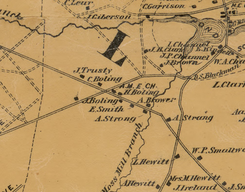
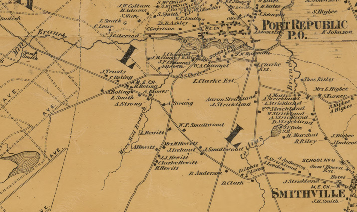
Detail from Topographical Map of Atlantic Co., New Jersey. New York: Beers, Comstock & Cline, 1872.
1–4. Robert Morss (also Morse or Moss) originally owned all of this land, giving his name to Moss Mill Road. In 1795, the land passed to William Burnett and, later, to Charles Burnett. In 1852 Lewis Clark purchased the land. From 1855 through 1861, a portion of Clark’s land-holding was divided into the lots represented herein. (1) In 1857 Lewis Clark sold this land to Henry Boling for $32.25. It is possible that Boling and his family were living on or near this land as early as 1849. In 1870 Henry conveyed this land to his daughter, Rebecca Boling-Harris. (2) In 1861 Henry Boling also purchased this land for $30, later conveying it to his oldest son, Josiah, in 1870. (3) Josiah purchased this lot in 1860. Although Josiah owned these two lots, he lived with his parents and rented lot #2 to Moses Miller and probably used lot #3 as extra farmland. (4) In 1864, Alexander Smith—husband of Henry’s oldest daughter, Deborah—purchased this lot for $400 despite his active duty in the Union Army. The house on this property was built by Robert Morss ca. 1770 and, prior to 1857, would have been the only settlement in this area. Smith nearly lost the property to unpaid taxes in 1883, but quickly paid the township and regained the land.
5–7. Elias Wright was the previous owner of this land, before Charles Boling—second son of Henry and Grace—purchased all three lots in 1866 for $150, keeping the first (5) for himself. The second lot (6), Charles quickly sold to James Trusty—husband of Henry’s daughter Margaret—for $75. In 1953, this land was expropriated for the Garden State Parkway. The third lot (7) was donated to the Ebenezer African Methodist Episcopal Church in 1870.
8–9. By 1869 Rollin M. Ashley owned these two lots. In 1870 he sold his small triangle lot on the north side of Moss Mill Road to the Ebenezer African Methodist Episcopal Church for $10. The larger lot was sold to Moses Miller in 1884 for $150. Miller was a brother-in-law to Alexander Smith, and was renting lot #2 from Josiah Boling prior to this transaction.
10–11. While these plots of land were individually owned by John Endicott and Robert Leeds, respectively, in May of 1828 they were consolidated by Samuel Cordery for $70.37. In 1837, they were both purchased by Jonathan Pitney for $300, and later passed down to Caroline Fowler Pitney, then Martin Pitney. In 1902 Alfred Adams, Jr. purchased the land, followed by Jacob K. Hecker in 1904, who failed in his plans to develop the lot. In 1953 much of the land was expropriated for the Garden State Parkway. The occupant of the house on this land represented in this model is believed to be Samuel Smith, Jr., renting the land from the Pitneys.
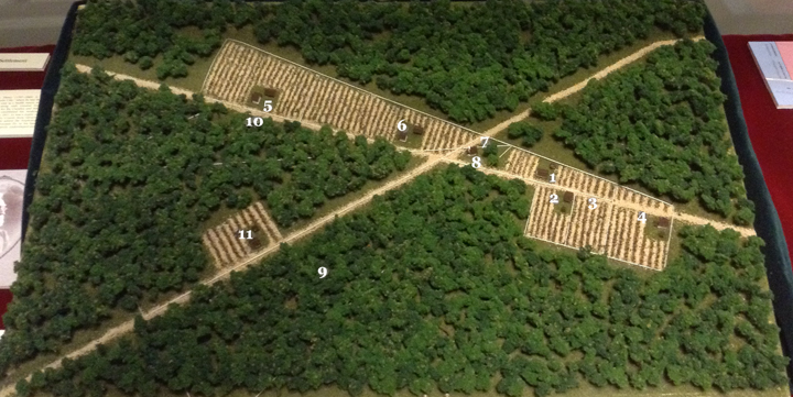
The Boling Settlement and surrounding properties.
Owners in 1872
1 — Rebecca Boling-Harris — 2.15 acres
2 — Josiah Boling — 2 acres
3 — Josiah Boling — 2 acres
4 — Alexander Smith — 4 acres
5 — James Trusty — 6.25 acres
6 — Charles Boling — 6 acres
7 — Ebenezer A.M.E. Church — 0.25 acres
8 — Ebenezer A.M.E. Church — 0.39 acres
9 — Rollin M. Ashley — 15.61 acres
10 — Caroline Fowler Pitney — 9+ acres
11 — Caroline Fowler Pitney — 23 acres
Dr. Jonathan Pitney (1797 – 1868) is considered the “Father of Atlantic City,” where he was the first to see the potential of the area as a health resort, and in March of 1852, he was granted, along with General Enoch Doughty, a charter for the Camden and Atlantic Railroad Company. Pitney established his medical practice in Absecon in 1819. In 1837, he was a major contributor to the divorce of Atlantic County from Gloucester County, the same year that he added the Southwest corner of Moss Mill Rd. and Riverside Dr. to his land holdings, which remained in the family, undeveloped until 1902.
Brevet Brigadier General Elias Wright (1830 – 1901) began his career as a teacher, having settled in Port Republic on the land that he later sold to Charles Boling in 1866, when he moved his family to Elwood. As an officer during the Civil War, Wright led troops in many battles and formed the first regiment of Colored Troops in Washington, D.C., serving as Major to the 1st Regiment of U.S. Colored Infantry beginning June of 1863. Wright began a quarter-century career in 1873 as a surveyor for nickel and steel tycoon, Joseph Wharton, surveying much of Southern New Jersey. Upon his death on January 2, 1901, The Daily Union devoted the front page of three editions to his life and funeral.
Other early settlers of these crossroads include Robert Morss, a mill owner; Lewis Clark, the first postmaster of Port Republic; and John Endicott and Robert Leeds, founding members of the Second Methodist Church of Port Republic in 1811.
In 1904 Jacob K. Hecker, Sr.—a druggist from Philadelphia—purchased the two plots of land once owned by the Pitney Family with the intention of developing them. The following year, he subdivided the land with the Atlantic County Clerk’s Office. Legally, this created eight new roads that would act as a grid for nearly five hundred land parcels he hoped to sell for the construction of summer homes. Hecker gave the streets maritime names in order to attract more people to the shore area. In reality, not a single tree fell for this business venture and it remained idle for decades. Interestingly, more than a century later, Hecker’s development plans are still represented on Google Maps.
Also in 1905, The City of Port Republic was officially carved out of Galloway Township, cutting the Boling Settlement in two.
In 1953, Eminent Domain hit the area. Plans for the Garden State Parkway required sections of land once owned by James Trusty, Moses Miller, and hundreds of the subdivided plots still listed at the time as the “Development of Jacob Hecker et ux.”
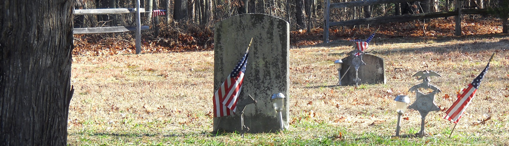
Today, the Historic Smithville Inns, Inc. owns most of the Port Republic side of the Boling Settlement, while Galloway Township owns the other. The land upon which the Ebenezer African Methodist Episcopal Church stood, and that still contains the “Boling Cemetery,” has been maintained by the county since 1989, after the Port Republic Historical Society saved the cemetery from near demolition.
A Clothing Clasp—Patent No. 9,740, dated June 7, 1881—was discovered on the homestead of Charles Boling in the 1990s. The portrait and motto on the front of clasp most closely resemble those of the Roman Emperor Gallienus (253 – 268 C.E.).
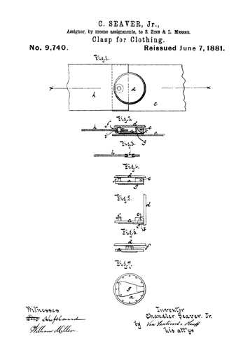
Patent for clothing clasp found on Boling Settlement.
![]()
Larger detail from Topographical Map of Atlantic Co., New Jersey. New York: Beers, Comstock & Cline, 1872.